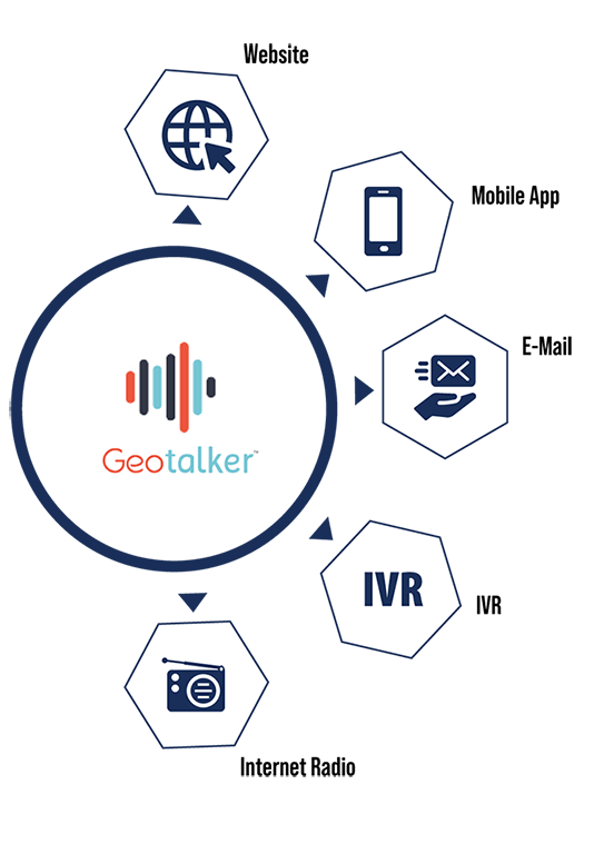
About GeoTalker™
The platform provides a service that accepts, processes and delivers geographically tagged information to travelers through a variety of channels including IVR, web site, email, hands-free, eyes-free mobile app, and Internet radio. Whether on IVR or on a mobile app, a user can select to hear or see information based on where (on earth) they are.
GeoTalker™ is the platform service that supports many of Information Logistics' other products and services, including its "511-in-a-Box", which is a true virtual, cloud-based 511 service delivery system. The GeoTalker™ platform was created by Information Logistics' staff and has been in use since 2011. Mobile applications built using GeoTalker™ services have been deployed in both the US and England.
Interoperability
Agencies/DOTs who use the GeoTalker™ platform service can cooperatively share data so that a driver does not need to change apps when they cross state/jurisdiction lines.
Travel Alerts
Imagine your GeoTalker™ based app broadcasting information your drivers need to hear, near where they are driving. No need to look at or touch their mobile phone to get important roadway advisories while driving.
LOCATION SPECIFIC
All data coming into the GeoTalker™ system is tagged with a location so that each advisory is broadcast only to users within range of the incident. Drivers hear your message at the right place.
TIME SPECIFIC
Data can be pre-scheduled or tagged with start and end times for activating each message. Drivers hear your message at the right time.
TYPE SPECIFIC
Data is categorized so that users can select the types of information they would like to receive. Drivers hear messages that are the right type of information for their trip.
A mobile app using the GeoTalker™ service can be developed/customized to your agency.
Perfect for:
- Travel Advisories & Slowdowns
- Information for Truckers
- Points of Interest
- Parking Information
- Curve Notification
- Congestion
- Queue Length Announcements
- Speed Limit Changes
- Construction Zone Alerts
- Toll Information
- Multi-Modal Transit Information
- Runaway Truck Zones
- Bridge Restrictions
- Tunnel/Hazmat Information
- Detour Alerts
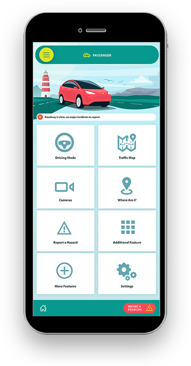
511 Mobile App Features/Options:
- Native map with data layers
- User feedback option
- Administrative console for managing alerts, categories, road names, and user reports feedback
- Manual entry system
- Scheduled alerts
- Links to adaptive web pages
- Streaming cameras
- User selected information categories
- User selected range for audio alerts
- Toll calculator
- "I'm not driving"/ movement detection feature
Customizations Can Include:
- Logo/colors
- App name
- End user license agreement
- Neighboring agency's data announcements
- Information categories
- Default user settings
- Map layers
- Include INRIX data
- Include other 3rd party data
How it works
Drivers start their 511 Mobile App before starting the car and safely stow their cellphone. The application stays "on" in the background, but remains quiet until the vehicle approaches an area where there is relevant information in the system. Then the phone will automatically start to "broadcast" the reported conditions without any interaction from the driver.
The information will be broadcast once, and then the broadcast stream will go quiet until there is an update to an event that is still in range, or until a new event for the driver's dynamic location is available. There is no need to subscribe for travel advisories or to specify days or times of travel. The only events broadcast are those nearby the current route. Just turn on the app and it finds what's nearby - and it will continue to find nearby events as the vehicle continues to move.
The driver does not need to look at the phone or to touch the phone. With hands on the wheel and eyes on the road, the driver stays informed and can stay undistracted while becoming aware of approaching hazards, points of interest, or other information.
Information Logistics' GeoTalker™ also provides users with the ability to customize their experience by specifying roads that they are interested in, the information replay interval and also the number of miles radius they are interested in receiving information.
Underlying Technology
GeoTalker™ is based on Information Logistics patent pending "Open Microphone Platform".
A custom stream of advisories and sponsor messages is created and dynamically modified for each connected driver as they travel. The stream is broadcast automatically to the driver without driver interaction and without interrupting normal cell phone use.
The system is designed using cloud technology, and can be hosted.
Probe Data
Information Logistics' GeoTalker™ 511 Mobile App uses the phone's GPS to periodically obtain the driver's location (approximately every 2 minutes) and sends this information back to the hosting server.
The data transmitted back includes information such as latitude, longitude, altitude and speed. This information can serve as "probe" data to be used in managing roadways, fleet and delivery management, and predictive roadway behaviors. The data transmitted back is anonymous. This probe data is also useful for advertising analysis.
Sponsorship Opportunities
Sponsorship messages can be inserted into the broadcast stream, and can be broadcast to all active users or only to drivers currently within a specific geographic area. Sponsors can also have banner ads or other visuals on any corresponding website and on the smartphone app itself.
The Data
The data for the system is provided by you. The data can be provided as an XML data feed (or other custom methods) with each tagged with a location (latitude and longitude).
Availability
Information Logistics' GeoTalker™ 511 mobile app is currently available in several geographic areas. It can be found on the iTunes for iPhone and iPod and on Google Play for Android.
Click here to download the GeoTalker™ app product sheet.