
511-in-a-Box® is a true virtual, cloud based system (even for telephony) based on a location oriented platform (GeoTalker Platform). It dynamically adds resources to meet user demand; it achieves high reliability through hosting in multiple/geographically diverse locations; it can be customized to specific needs; and it can be rapidly deployed. Offered as Software as a Service (SaaS), 511-in-a-Box® offers significant cost savings over traditional 511 solutions.
It provides the traditional 511 components of web site, IVR and e-mail/text alerts, as well as a location-based hands-free, eyes-free, interoperable mobile app.
All this at a fraction of the cost of traditional systems.
Low cost
Capacity On Demand
Rapid Deployment
Cloud Based
Customized
SaaS
IRIS Eyes and IRIS Locate can be added to your 511-in-a-Box® deployment.

The 511 IVR Service
- Users can ask for traffic near any location or landmark.
- Users can ask for traffic with or without directionality on any road, near a location, or statewide.
- Users can ask for traffic on a roadway between two locations - again, with or without directionality.
- SAM will figure out the geography surrounding your request and give the user relevant information as provided from the agency approved data feeds.
- SAM incorporates floodgates, just like a traditional IVR system. Floodgates may be marked as "interruptible," or "not interruptible".
- Native voice-over-IP (VoIP): Eliminates the need for traditional provisioning requirements (e.g., ordering trunks to a standard switch).
- Announces slowdown data as well as incidents/events.
- Cloud-hosted: More resources for processing requests can be added as severe weather (and corresponding usage) is forecast.
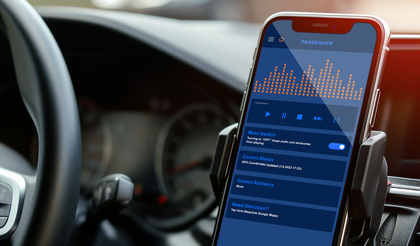
The 511 Mobile App
- Hands free, eyes free app-based experience (not simply a mobile 511 website) providing location-based alerts.
- I'm Not Driving Features: View of incidents and cameras within range of travel.
- Integration with Google map and custom layers on both iPhone and Android.
- Access to full (adaptive) 511 web site.
- Cross-agency/region information can be broadcast and presented (where available).
- App can be customized for additional features as needed by the agency (e.g., slowdowns, specific commercial/truck information, other geo-based information).
- Push notifications are available.
- Voice activation is available.
- Integrated with other V2N alerting systems like HAAS Alert, Drivewyze, etc. (and more in the future).
- Integration with Apple Car Play and Android Auto.
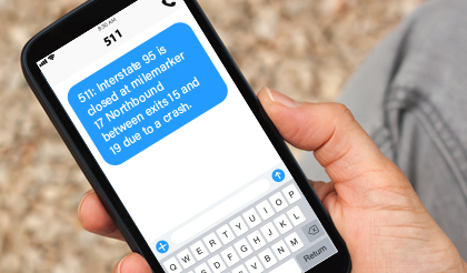
The 511 Traveler Alert Subscription Service
- User Interface to manage entire subscription: Standard signup, unsubscribing, lost password, change password and editing subscriber information, as well as route definition/selection based on agency organizational requirements.
- Alerting method: Accommodates email and text messages.
- Geo-Based: Platform allows subscribers to customize their alerting by drawing the areas of interest on a map. Days and times for receiving messages can also be personalized.
- Data Migration: In most cases, data from existing subscriber services can be migrated/mapped to the new system.
- Social Media Integration: Can automatically tweet alerts to agency-defined accounts and can provide data feeds to WAZE.

The 511 Administrative Interface
- Manage any non-automated floodgate messages.
- Manage any non-automated Ticker alerts.
- View user web site feedback.
- Hear recorded messages from user IVR feedback.
- Access usage reports.
- Camera status listing.
- Manage ad-hoc special events on mobile app only (non-511 events).
- Links to other reports (Google Analytics, server monitoring, etc.)

The 511 Data
- 511-in-a-Box®; can work with a variety of data.
- Use data from your data fusion hub/data feed - 511-in-a-Box®; will accommodate.
- Use data from various industry sources - 511-in-a-Box®; will adapt.
- Use the administrative interface to manage advisories from initial alert, through updates and until closed.
- Data can be retained for future reporting and analysis.
The 511 Website
- Adaptive design: The website can serve as a functional and well-sized site for both PCs and for mobile devices.
- Standard Google map: The map is a Google map, with custom layers applied according to the agency needs and requirements.
- Text Listings: A page for test listings for cameras, planned and unplanned events for easy reading and facilitating accessibility.
- Ticker: A scrolling ticker is prominently displayed to highlight important/urgent information, with ticker managed via administrative interface (website).
- Cameras: The website can present images or streamed video (via hosted integrated media server).
- Speed Data: Speed data is included as a layer on the web map.
- Road Conditions: Roadway conditions can be programmed as a custom color overlay.
- Roadway Restrictions: From data feed or via manual entry, display map, text listing and printable PDF of roadway restrictions. Integrate with mobile app and IVR for restrictions information via voice or as traveler approaches restricted area.
- Check My Route: Public users can obtain travel information specific to their route simply by entering a starting and ending address. The system uses Google functions to automatically calculate the primary route for the trip. The route will be drawn on the map and the system will display information about all relevant data (incidents, constructions, etc.) encountered on the trip.
- AVL Tracking: The system can display real-time and historical locations of vehicles equipped with automated vehicle location technology.
- Google Analytics: Site usage and other web stats are tracked.
- Cloud-hosted: More resources for processing requests can be added as severe weather (and corresponding usage) is forecast.
- NWS Data: National Weather Service forecasts, alerts and warnings can be displayed on the web map, using geometric shapes to indicate affected area.
511-in-a-Box® Key Services and Features
| Core Traveler Information Services | Strengthen Mobility | Congestion Relief | Safe Roads For All | Leverage Innovation | Climate Change via congestion technologies |
|---|---|---|---|---|---|
| Website and Web Map featuring | |||||
| Check My Route for hazards along your trip | |||||
| Diverse mapped layers (EV, parking, DMS, Travel Times) | |||||
| Special Event Templates with route travel time comparisons | |||||
| Mobile app | |||||
| Cross jurisdiction, geo-centric, hand-free/ eyes free alerts | |||||
| Geo-targeted push alerts | |||||
| Traveler roadway reports | |||||
| Toll calculator, HOV declaration | |||||
| Voice activation via Siri/Google Assistant | |||||
| Voice Assistant for obtaining travel information (SAM) | |||||
| Accessed via IVR 511 phone call, website link, mobile app | |||||
| Detailed information through natural dialogue | |||||
| Summary regional traffic report | |||||
| 511 Subscriber Notifications with graphical interface |
SaaS- configured for your needs.
Enhanced 511-in-a-Box® Commercial Information
| Commercial Vehicle Specific Information Services | Strengthen Mobility | Congestion Relief | Safe Roads For All | Leverage Innovation | Climate Change via congestion technologies |
|---|---|---|---|---|---|
| Commercial Vehicle Restriction Information | |||||
| CV restrictions special web map, text listing and PDF | |||||
| One click signup for restrictions text/email notifications | |||||
| Truck Parking Information | |||||
| Mapped locations with real time space availability | |||||
| Display Approved Alternate Routes (when a detour is in place) | |||||
| View alternate route and send directions to navigation apps |
Critical information for safe and efficient commerce.